
Your Maps Can Lie Now. Here’s What Malaysian Business Owners Need to Know
Picture this: you’re about to sign a lease on a new retail space in Subang Jaya. You pull up Google Earth to double-check the area — how busy the street looks, whether there’s actually parking behind the building, if that competitor really opened across the road. You’ve done this a hundred times. The map has never lied to you.
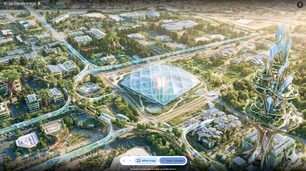
Now imagine that Google had quietly added a tool that lets anyone generate a fake satellite image of your street, your building, your neighbourhood — and it looks just as convincing as the real thing. Then imagine that Google pulled the feature one day later because people were already abusing it.
This actually happened. On 31 July 2026, Google launched an AI image generation feature inside Google Earth. It used its Nano Banana 2 image generator to let anyone paste fabricated images over real satellite maps. The idea was creative fun, according to Google. The reality, according to critics, was a fast track to a deluge of geospatial misinformation. Within a day, the feature was gone.
TL;DR: Google launched an AI tool that could generate fake satellite imagery, got slammed by journalists and researchers for enabling misinformation, and scrapped it within 24 hours. For Malaysian SMEs, this is a warning on three fronts: AI-generated images are becoming harder to detect, tech features can disappear overnight, and your verification habits need to catch up fast.
What This Means, in Plain Language
For years, satellite imagery has been treated as neutral, factual ground truth. Journalists use it to document events. Property buyers use it to assess land. Logistics companies use it to plan routes. If a building is on a plot of land, the satellite image shows it. No debate. That’s what made Google’s brief experiment so dangerous.
The tool was prompt-based, which meant basically anyone could superimpose any image onto real maps. One BBC journalist sarcastically posted that there was “no way” a feature that lets you generate fake imagery on one of the most reliable sources of visual evidence for journalists could possibly be abused. The sarcasm was well earned.
Google’s own statement acknowledged the mess. The company said people were sharing screenshots of generated imagery that violated its policies, and announced it would roll the feature back while implementing “stronger guardrails.”
Here’s the uncomfortable part: the problem is bigger than Google Earth. As the TechCrunch report notes, you no longer need to be a Photoshop expert to create semi-credible disinformation. Anyone with access to an AI image generator can do it. Google Earth AI just happened to be the most public example of fake imagery attaching itself to real-world geography — and it was killed precisely because of that risk.
How This Applies to Malaysian SMEs
Let’s get practical. You don’t run a newsroom, and you probably don’t care about a foreign journalist’s sarcasm. But you do care about three things: whether your marketing images are honest, whether your property and logistics decisions are based on reliable information, and whether the tools you depend on today will still exist tomorrow.
First: your product and marketing visuals are a trust battleground. Malaysian consumers on Shopee, Lazada and TikTok Shop are already cynical. They’ve ordered items that didn’t match the photos. They’ve seen property listings where the “stunning view” turned out to be a carpark. If AI tools can now generate convincing imagery of a location — a restaurant with a sea view that doesn’t exist, a “renovated” warehouse that’s still an empty shell — the gap between expectation and reality widens. And when that gap widens, customers don’t blame AI. They blame you. In Malaysia, misrepresenting a property or a product isn’t just a reputation issue; it can land you in disputes before the Tribunal for Consumer Claims or expose you to action under the Consumer Protection Act 1999.
Second: location-based decisions are getting riskier. Malaysian SMEs in logistics, agriculture, construction and property development rely on satellite imagery every day. A contractor in Johor verifies site progress from the air. A plantation manager in Sabah checks crop health from above. A delivery operator in Penang optimises routes. When anyone in that chain can generate fake satellite imagery with a simple prompt, visual proof stops being proof. If you’re approving a supplier’s inventory claim based on a warehouse photo, or verifying that a business partner really has that factory in Kulim, a screenshot of a map is no longer enough.
Third: a feature can vanish in 24 hours, and you can’t build a business on illusions. Google made this tool available on a Thursday and pulled it on Friday. If you had built a workflow around this feature — generating property previews, creating site reports, producing marketing materials — you’d be back to square one within a day. This isn’t an isolated event. AI features are being launched, abused, criticised and killed at record speed. The message for you: never build critical business processes on a brand-new AI feature. Wait until it stabilises. Wait until the promised guardrails are actually visible.
This also affects how you should read the tools you already use. Many Malaysian SMEs have started experimenting with AI-generated product photos and property visualisations. That’s fine — tools are tools. But the Google Earth incident draws a clean, public line between “creative enhancement” and “misleading fabrication.” Crossing that line, even unintentionally, damages the credibility you’ve spent years building with customers and partners.
“Screenshots used to be evidence. In Malaysia, they are still accepted as proof in countless daily business decisions — lease agreements, product deliveries, supplier audits. After this incident, a smart business owner treats every image as a claim that needs checking, not a fact that requires no further questions.”
What You Should Do Now
- Add a verification step to your image workflow. Before publishing any AI-generated image, ask: does this misrepresent a physical place or product condition? If the answer is yes, label it clearly or don’t use it.
- Check capture dates and metadata. Know when a satellite image was taken and whether it has been altered. Free viewers may not show this; the source platform’s annotations or paid GIS tools will.
- Cross-check locations with on-the-ground confirmation. If you’re making a property or logistics decision based on a map screenshot, send someone to physically check or request live street-level footage from a trusted person.
- Brief your team on AI imagery limits. Whoever creates your product photos, WhatsApp promotion posts, or supplier requests needs to know the rule: no faking locations, no inventing features, no AI “improvements” that make a visible reality look different.
- Treat freshly launched AI features as experimental. If a tool is days or weeks old, do not rebuild a workflow around it. Test it, watch how early adopters describe its flaws, and adopt it only when it proves stable.
- Archive your own original images. If you’re a property developer or product supplier, keep original photos with timestamps. If anyone ever challenges your authenticity, having originals is your defence.
| Business Scenario | AI Risk Level | Current Protection | Action Needed |
|---|---|---|---|
| Property listing “preview” images | High — a fake view can change a buyer’s decision | Verbal disclaimers | Use original photos only, or label artist impressions clearly |
| Satellite images for route planning | Medium — generated traffic or road obstruction imagery | Trust in map providers | Cross-check with real-time traffic apps before final decisions |
| Supplier proof-of-inventory screenshots | High — fabricated warehouse or stock imagery | Written assurances | Require live video calls for high-value inventory verification |
| E-commerce product marketing images | Medium — AI-enhanced look vs actual product | Platform return policies | Publish unedited photos alongside any AI-enhanced visuals |
The Bigger Picture
This incident was never really about Google Earth. It’s about the collapse of visual proof. For two decades, a photo or a satellite map carried an implicit “this is true” stamp. That era is closing. As the TechCrunch article points out, most imagery on the web can now be manipulated using AI tools that are widely accessible. The only reason this story made headlines is that it happened on a platform people trusted.
In the long run, Malaysian SMEs will need to navigate a world where authenticity is a premium, not a default. Verified badges, tamper-evident documents, watermarking and provenance tracking will become normal parts of business transactions. For now, you don’t need a complicated solution. You need a habit: assume every visual you receive may be fabricated, and assume every tool you rely on may disappear.
The opportunity hidden here is trust. When your competitors are lazily pasting AI images into presentations and treating satellite screenshots as gospel, the business that says “show me the original” and “let me verify this on the ground” becomes the one that’s actually reliable. In a market like Malaysia, where referrals and relationships drive so much of SME business, reliability is what wins the next contract.
Google moved quickly to pull the feature, and that’s good. But the next generation of AI tools won’t always be pulled so fast — and in many cases, they’ll be used by your suppliers, your employees and your competitors, not just tech giants. Start building your verification habits now, before a fake image sinks a deal, a lease or a customer’s confidence.
Ready to Streamline Your Operations?
Your business should run itself. AutoRunBiz deploys AI agents to automate your daily operations — WhatsApp orders, invoicing, customer follow-ups, and accounting. Book a free 15-min ops audit to see where automation fits your business →